With all due respect to Rock Creek Park, I’m getting a little tired of Rock Creek Park, or at least the parklands in DC. Don’t get me wrong, I deeply appreciate the city closing parts of Beach Drive to allow socially distant recreation during the COVID-19 crisis, but when you’re an injured runner it’s kind of hard to go where seemingly all the healthy runners are going.

So I’ve been trying to branch out, using a few criteria to stave off cabin fever: easy parking; quiet trails; plenty of shade; friendly dogs, preferably leashed.


One weekend, a running friend mentioned that he used to run at Lake Needwood, and I immediately remembered seeing it on a map near Rockville when checking how far north Rock Creek goes (answer: about eight miles north of Needwood to Laytonsville).

The 40-minute drive from downtown D.C. was a small investment to check all the boxes. That Thursday afternoon was made for lake exploring; I almost forgot about the midday humid heat — and if you can believe it, the pandemic — as I followed the tree-lined trails. As tempting as it looks, keep your feet and pets out of the water.  County tests for water quality in recent years have detected toxic blue-green algae.

The fact that parking at Lake Needwood is free is a big deal for me, though the small parking lots seem likely to fill up on busy summer weekends.  The park is open from sunrise to sunset.

Montgomery Parks’ website on the Needwood Trails says that there is no way to walk around the lake, but Needwood Drive has a safe path on the side of the road for pedestrians and bikers to cross the water on the north end of the lake, which is what I used to connect the Westside and Mudcat trails.

It’s difficult to talk about 75-acre Lake Needwood without mentioning nearby 55-acre Lake Frank and the natural surface trails surrounding both. I would not recommend centering a long run at Needwood itself, which is only about 2-3 miles around, but the asphalt Rock Creek Hiker/Biker Trail connects both waterways to the District of Columbia border less than 15 miles away. Given the narrow, winding route, you’re unlikely to encounter aggressive cyclists.

Boat rentals and fishing could distract non-running members of your household on certain days of the week if they’re into that. Check online for their revised schedule during COVID-19 times.

0 Comments


I thought I had been fooled.

No, I must have gotten something wrong. Turning out of Morven Park, the famed Old Waterford Road, which I found on Loudoun County’s map of unpaved roads, was most certainly paved!

Well, I was already out in Leesburg, I might as well keep going. I started climbing the hill (that will happen a lot on this route) and a while before I realized it, the road had indeed switched to rocky dirt, just as advertised.

I picked the road from the county’s new map, which is suited for mobile use, but found some supporting endorsement from the Loudoun Road Runners, who make the road a staple of their routine.

Before too long, I realized why. By the time I hit the intersection with Nestlewood Road, I was used to the climbing and the traffic, light as it was, was down to almost nothing. There are a few tricky curves, so you have to approach them with caution, but before long the road stretches out ahead of you with plenty of visibility.

I like rolling hills, so it was right up my alley – the climbing peaks before 2.5 miles on the way out, though 1.5 to 2.3 on Old Waterford climbs 267 feet. I’m mildly terrified of horses, and I passed a few, but they didn’t threaten me and everyone stayed cool.

Five miles in, you reach the end of Old Waterford, but if you’re willing to navigate 0.1 mile of pavement on a sweeping curve, Browns Lane gives you an extra 1.9 miles of dirt road – I initially missed it and ran too far on Loyalty, as you’ll see on the map. If 14 miles of mostly-dirt road isn’t enough, you can add on plenty on Morven Park, which is also a great place to park (or watch a cross country race).

I loved it on a day I was being pelted in the face by sleet. Chances are you’ll like it, too.

0 Comments
A visitor photographs the columns that serve as a centerpiece to the arboretum. Photo: Charlie Ban

I don’t know what was wrong with me. I had this beautiful gift, and I had been ignoring it for years.

The last time I remembered running in the National Arboretum was right before Thanksgiving 2014. Then, for some reason, I just stopped running there. It wasn’t until the end of this past January, after months of me telling myself I should go back there, that I actually did.

What a treat.

Read More

2 Comment
Ryan Stasiowski finishes the 2013 Patuxent 10k. Photo by: Charlie Ban

Patuxent River Park in Upper Marlboro, Md. boasts more than 6,000 acres of nature trails and wildlife just ten miles off the Beltway.

If you prefer a running soundtrack of croaking frogs to mp3 playlists, you’ll be right at home, along with the wandering beavers and occasional snake.

Read More

0 Comments

First, let’s get one thing straight although there are numerous hills that make this run strenuous at times, Difficult Run is actually named after the tributary stream, or run, that runs for nearly 16 miles through Fairfax County, eventually ending at the Potomac River approximately two miles south of Great Falls.

Read More

0 Comments
The Powerline Trail as it is best enjoyed, under cloudy skies, shortly after opening in October 2018. Photo: Charlie Ban

After years of dedicated planning and construction, Montgomery Parks opened the Powerline Trail, also known as the Pepco Trail, in October 2018.

The 6.8-mile trail, which kicks off from South Germantown Recreational Park in Germantown, Md. and terminates at North Potomac’s Muddy Branch Stream Park, marked the first use of power corridors for recreational use in Montgomery County. In my final days before shipping out for my freshman year of college, I decided to hit the trail to see if it would live up to the hype. 

The origins of the trail date back to 2015, when power companies Pepco and Exelon were nearing a merger. Dave Magill, the Maryland advocacy director for MORE (Mid-Atlantic Off-Road Enthusiasts), remembers first hearing of the possibility of including the construction of a trail as a condition in the merger.

“A bike advocate, whose name I cannot remember, was chatting with me and said, “you know, Pepco hasn’t been very good with allowing trails of any kind, whether bike or hikers, either on or even across their power lines. Maybe to get an approval, they’ll have to go before the public utility commission (PUC). This is an opportunity to intervene in the merger and ask for them to change their policy about trails. That idea really resonated with me.”

Read More

0 Comments

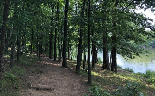
There is a hidden gem for Washington-area runners in the heart of Loudoun County — Banshee Reeks Nature Preserve. Over 20 miles of well-groomed grass trails traverse the 725 acres of grassy fields, hardwood forests, wetlands, and creeks. It’s a wonderful cross-section of the beautiful landscape that can be found in Northern Virginia. The picturesque scenery is an ideal backdrop for logging miles on soft trails. If you’re the type of runner that likes to connect with nature, this place is worth the trip no matter where in the metro area you live.

The first thing that may stand out to you is the odd name, the origin of which goes back to the early 19th century. Once you experience this place, the second word of the name makes sense, given “reeks” is a Gaelic word referring to hills and dales, which are abundant. The term “banshee,” Gaelic for female spirit, begs for further explanation. A local farmer, likely resulting from an intoxicating visit to a local saloon, came back home one windy night and claimed he heard a banshee on the reeks. The farm animals and wind were the likely culprits for the sounds, but over the years the story was repeated, and the area became known as Banshee Reeks.

Read More

0 Comments

As RunWashington’s email goes out on March 9, 2022, the race is underway at the Barkley Marathons in Tennessee. In 2017, then-Rockville, Md. resident John Kelly won the race held in the park across the road from where he grew up. Here’s a look back at that race. Kelly is competing again this year, he now lives in England.


As fog rolled rapidly though the Cumberland Mountains in Eastern Tennessee, it created a strobe-like effect as dawn was breaking. From a fire tower, Rockville’s John Kelly could be seen, then not seen, then seen again… climbing a long hillside cleared for power lines.

Conrad Laskowski and Ed Aramayo watched Kelly pick up something orange, shake it around and put it on his head.

“It was a wool hat,” Laskowski said.

Photo: Conrad Laskowski
John Kelly climbs “Rat Jaw” on his fifth loop of the 2017 Barkley Marathons. Photo: Ed Aramayo

Even five days later, the excitement perked up Kelly’s otherwise calm even-keeled demeanor.

“I spotted that orange hat I’m like, ‘Score! this is awesome!” he said. “It’s one of the most exciting things I’ve ever seen.”

That hat, along with the plastic grocery bag he had fashioned into a poncho, helped Kelly, 32, mitigate the cold and rain and repurpose them to help propel him forward, with just a few miles to go in what was likely 130 miles over 59 hours and 31 minutes, over some of the most rugged terrain in distance running.

In 2017, he became the 15th person to complete the Barkley Marathons over 30 years, the first from the Washington, D.C. area.

Read More

0 Comments


It takes an hour to get here from Washington, D.C.

You head north on Interstate 270, pass by the main exits for Frederick and continue onto U.S. Route 15. Catoctin Mountain comes into view. And as Cactus Flats Roadhouse passes by on your left, be on the lookout for your exit: Mountaindale Road.

You wind down through fields, passing by Mountaindale Convenience Store. When you have to choose right or left, choose left, and continue on what is still Mountaindale (Putnam Road is to the right). If you start seeing log cabin-inspired homes and the Cold Deer Hunting and Fishing Club, you chose correctly, and are almost there.

Read More

0 Comments

Real estate developers may have their eye on Calvert County, Md. land, but at least 3,000 acres is safe.


What’s there?

Interactive trail map

The American Chestnut Land Trust protects hardwood forest, wetland and farmland. In the process, those lands offer 19 miles of trails that make it the ideal running spot in the county.

It’s off the beaten path, about an hour’s drive from D.C., but it’s not hidden. Signs on U.S. Route 4 point it out to anyone who passes, a turn onto Dares Beach Road, past Calvert High and Double Oak Road.

Read More

0 Comments
×

Subscribe to our mailing list